(MAPS TRACKER: Spaghetti Models And More)
As of 11 a.m. EDT, Hurricane Milton has intensified into a Category 4 storm, boasting sustained winds of 145 mph. The hurricane is currently located 190 miles southwest of Tampa and is tracking northeast at 16 mph.
Rain Bands and Tornado Watches
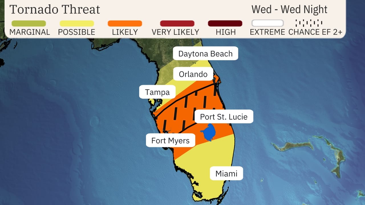
Heavy rain bands from Hurricane Milton are already affecting parts of Florida, well ahead of its anticipated landfall. Key West has reported wind gusts reaching 59 mph. A tornado watch is in effect for the southern half of the Florida Peninsula, including cities such as Miami, Tampa Bay, and Fort Myers, until 9 p.m. EDT.

Hurricane Warnings and Storm Surge Alerts
Milton has expanded in size over the past 24 hours, with tropical-storm-force winds extending up to 175 miles from its center. This enlargement means that the storm’s impacts will affect a broad area as it approaches Florida.
Hurricane warnings are currently in place for much of central Florida, covering both the Gulf and Atlantic coasts. This includes regions like the Tampa Bay area, Fort Myers, Orlando, Cape Canaveral, and Daytona Beach. Residents in these areas should prepare for hurricane conditions (sustained winds of 74 mph or higher) beginning Wednesday evening into early Thursday.

Storm surge warnings extend along Florida’s Gulf Coast from Flamingo to Yankeetown, including Charlotte Harbor and Tampa Bay. Parts of the Atlantic coastline are also under storm surge warnings, with life-threatening water rises expected late Wednesday into Thursday.
Timing and Intensity Forecast
While Hurricane Milton is projected to weaken as it approaches Florida due to increasing wind shear, it is still expected to maintain its status as a major hurricane (Category 3 or 4) through landfall, which is likely to occur overnight Wednesday into early Thursday. However, it’s crucial not to underestimate the storm’s potential impacts, which will still include severe storm surge, destructive winds, and flooding rainfall.
Impacts Forecast
- Storm Surge: The National Hurricane Center forecasts that storm surge could reach heights of 8 to 15 feet above ground level, especially if the peak coincides with high tide along the west-central Florida Gulf Coast. Given the rising tidal cycle leading up to high tide Thursday morning, the surge will be most destructive near and south of where the storm makes landfall. Storm surge may also affect Florida’s east coast and parts of coastal Georgia and South Carolina due to onshore winds during Milton’s passage.
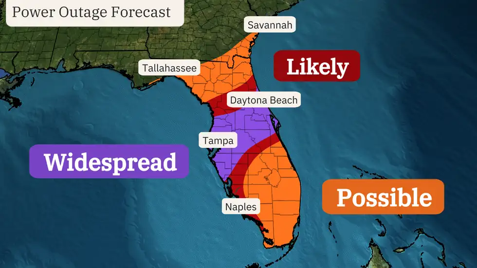
- Wind Damage: The most damaging winds, capable of causing significant structural damage and widespread power outages, will be felt near the storm’s center as it crosses the coast and moves inland through central Florida, including Orlando and Cape Canaveral. The timing of these strongest winds is expected to begin late Wednesday along the western Gulf Coast, progressing eastward through central Florida into Thursday.
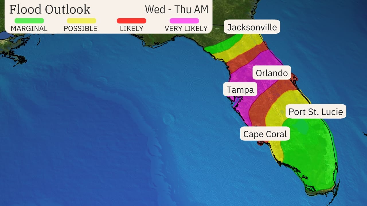
- Flooding: Catastrophic and life-threatening flash flooding, as well as moderate to major river flooding, is anticipated across the central and northern Florida Peninsula. Rainfall totals may reach 6 to 12 inches, with localized amounts up to 18 inches by Thursday. The NOAA Weather Prediction Center has issued a rare “high risk” flood threat for parts of central Florida, including the Tampa Bay and Orlando areas.
- Tornado Risk: The threat of tornadoes will be present in central and southern Florida on Wednesday and Wednesday night, with some potentially reaching EF2 intensity or greater. An isolated tornado threat may linger into Thursday in east-central and southern Florida.

Recap of Hurricane Milton’s Journey
Hurricane Milton originated as Tropical Depression Fourteen in the southwest Gulf of Mexico on October 5, quickly intensifying into Tropical Storm Milton. The following day, it became Hurricane Milton, undergoing rapid intensification with winds increasing from 90 mph to 180 mph within 15 hours. Its pressure dropped to 897 millibars, marking it as the lowest recorded in any Atlantic hurricane since Wilma in 2005 and ranking fifth-lowest in recorded history.
As Hurricane Milton approaches Florida, residents are urged to stay informed and take necessary precautions to ensure their safety.