Time is running out for Floridians as Tropical Storm Helene intensifies, threatening to become the most powerful storm to make landfall in the U.S. in over a year.
Helene formed in the northwestern Caribbean Sea on Tuesday morning and is expected to rapidly strengthen, potentially escalating from a 45 mph tropical storm to a Category 3 major hurricane within just 48 hours, fueled by the extremely warm waters of the Gulf of Mexico. This accelerated timeline leaves little room for preparation, as damaging winds, flooding rainfall, and life-threatening storm surge are forecasted. The National Hurricane Center has warned of possible track shifts, which could alter the areas hit hardest.
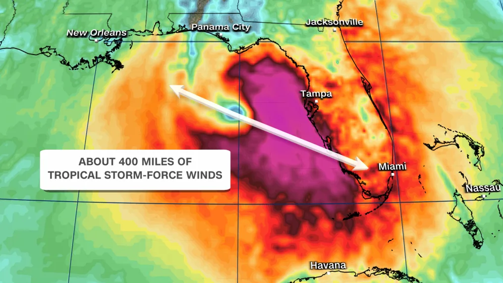
The storm’s reach will extend beyond Florida, impacting much of the Southeast with heavy rain, strong winds capable of causing widespread power outages, and tornado threats.
Evacuations for coastal areas of Florida are likely to begin Tuesday, particularly in Taylor County, located in the Big Bend region where Helene is expected to make landfall. This area faces a severe storm surge risk of up to 15 feet. Surge levels of up to 8 feet are possible in the greater Tampa Bay area, with several feet expected in more southern regions.
Hospitals are preparing for the worst, with Tampa General Hospital installing a 10-foot flood barrier to guard against the potential storm surge.
Governor Ron DeSantis expanded an emergency declaration from 41 counties to 61 on Tuesday to expedite preparations and coordination between state and local agencies. Over 3,000 members of the Florida National Guard are on standby, and the Florida State Guard has been activated. DeSantis also confirmed the availability of “hundreds of Starlinks” to ensure internet connectivity if service is disrupted.
Tropical storm-force winds could hit the Florida Keys as early as Wednesday afternoon and spread across the peninsula by Thursday morning, followed by hurricane-force winds in coastal areas. The Tampa region is expected to see the worst conditions late Wednesday into Thursday, with hurricane-force winds and heavy rain lasting through Thursday evening.
Further north, Tallahassee will have slightly more time to prepare, with landfall projected southeast of the city late Thursday. However, the worst of the storm will hit earlier and last throughout the day. Tropical storm-force winds and heavy rain will likely extend into the Southeast by Thursday evening, bringing down trees and causing widespread power outages.
The heaviest rain is expected Thursday into Friday morning, with parts of Florida, Georgia, Alabama, and the Carolinas at significant risk of flooding. Rainfall totals of 4 to 8 inches are predicted from Florida’s Gulf Coast up to Tennessee, the Carolinas, and Virginia, with up to 12 inches possible in the Florida Panhandle and the southern Appalachian regions. While much of the Gulf Coast rain will subside by Friday, the Southeast will face a rainy weekend as Helene’s remnants move northward.